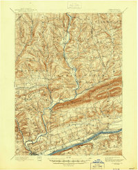
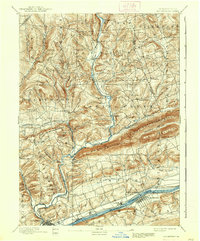
1894 Map of Bloomsburg
USGS Topo · Published 1944About this map
Bloomsburg sits at the southwestern edge of this landscape, where the Susquehanna River and the Penn. Canal parallel the Penn. R. R. and D. L. and W. R. R. through the river valley. The region is defined by the sharp, parallel ridges of Knob Mountain, Huntington Mountain, and Lee Mountain, which separate the agricultural valley lands from the northern uplands. This 1890s survey captures a complex network of milling and transport settlements, including Coles Mills, Stillwater, and Benton, which grew along the West Branch Fishing Creek and its tributaries.
Find a feature on this map
66 named features on this map. Tap any name to fly to it.
Don’t see what you’re looking for? This feature index may not catch every label — zoom into the map to look around manually.
Map Details
Editions of this 1894 Bloomsburg Map
6 editions found

Other maps of this area

1889 · Catawissa
USGS Topo · 1:62,500

1891 · Harveys Lake
USGS Topo · 1:62,500

1892 · Catawissa
USGS Topo · 1:62,500

1892 · Shamokin
USGS Topo · 1:62,500

1892 · Mahanoy
USGS Topo · 1:62,500

1893 · Harvey Lake
USGS Topo · 1:62,500

1893 · Shamokin
USGS Topo · 1:62,500

1893 · Mahanoy
USGS Topo · 1:62,500

1894 · Catawissa
USGS Topo · 1:62,500

1894 · Shickshinny
USGS Topo · 1:62,500