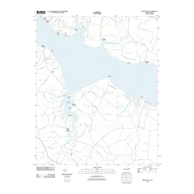
2010 Map of Blounts Bay
USGS Topo · Published 2010About this map
The Pamlico River dominates this coastal landscape, where the wide estuary meets a network of creeks and inlets. On the southern shore, Blounts Creek winds through the wetlands, anchoring local points of interest like Gerard Landing and the historical site of the Blounts Creek Mill. The settlement pattern here is deeply tied to the water, evidenced by numerous small landings such as Cotton Patch Landing and Dinah Landing. This area serves as a significant recreational corridor, featuring Goose Creek State Park on the northern bank and established camps like Camp Hardee and Camp Leach. The naming of geographic points, including Maules Point and Red Bug Point, reflects a long-standing local vernacular used by generations of river navigators and residents near Gilead. The presence of McCotters Marina at Broad Creek further highlights the transition from traditional water-based commerce to modern maritime leisure.
Find a feature on this map
70 named features on this map. Tap any name to fly to it.
Don’t see what you’re looking for? This feature index may not catch every label — zoom into the map to look around manually.
Map Details
Editions of this 2010 Blounts Bay Map
This is the sole edition of this map. No revisions or reprints were ever made.
Other maps of this area

1902 · Vanceboro
USGS Topo · 1:62,500

1903 · Chocowinity
USGS Topo · 1:62,500

1904 · Vanceboro
USGS Topo · 1:62,500

1905 · Chocowinity
USGS Topo · 1:62,500

1905 · Vanceboro
USGS Topo · 1:62,500

1943 · Plymouth
USGS Topo · 1:125,000

1950 · Pinetown
USGS Topo · 1:24,000

1950 · Aurora
USGS Topo · 1:24,000

1950 · Edward
USGS Topo · 1:24,000

1951 · Bunyan
USGS Topo · 1:24,000