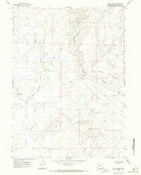
1968 Map of Blue Forest
USGS Topo · Published 1971About this map
Blue Forest defines the central landscape of this western Wyoming terrain, a region characterized by sparse water sources and rugged drainages. This late 1960s survey documents the critical infrastructure for desert navigation and livestock management, most notably seen in the remote water points of Little Colorado Well No 3 and Little Colorado Well No 4. The map illustrates a network of essential travel routes, including the Hunt Road and the prominent Lincoln Sweetwater Road, which provided the primary means of transit across the high desert plateaus of Sweetwater County.
Find a feature on this map
10 named features on this map. Tap any name to fly to it.
Don’t see what you’re looking for? This feature index may not catch every label — zoom into the map to look around manually.
Map Details
Editions of this 1968 Blue Forest Map
2 editions found
Other maps of this area

1954 · Ogden
USGS Topo · 1:250,000

1954 · Rock Springs
USGS Topo · 1:250,000

1955 · Preston
USGS Topo · 1:250,000

1955 · Lander
USGS Topo · 1:250,000

1958 · Lander
USGS Topo · 1:250,000

1958 · Ogden
USGS Topo · 1:250,000

1958 · Rock Springs
USGS Topo · 1:250,000

1958 · Preston
USGS Topo · 1:250,000

1960 · Ogden
USGS Topo · 1:250,000

1961 · Lander
USGS Topo · 1:250,000