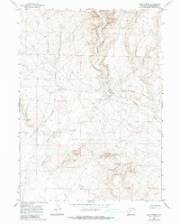
1968 Map of Blue Forest
USGS Topo · Published 1980About this map
Blue Forest defines the rugged topography of this Sweetwater County landscape, where deep drainage systems and high desert plateaus meet. The 1968 field-checked survey reveals an era of infrastructure development and resource management across the high plains. The Lincoln Sweetwater Road serves as the primary artery through the region, connecting remote points across the desert. Evidence of water management and industrial activity is visible in the placement of Little Colorado Well No 3 and Little Colorado Well No 4, alongside a designated Pit. The natural drainage of Buckhorn Canyon and Fourmile Gulch carves through the terrain, illustrating the erosional patterns characteristic of this part of Wyoming. These features together document the human imprint on a challenging environment during the late twentieth century.
Find a feature on this map
10 named features on this map. Tap any name to fly to it.
Don’t see what you’re looking for? This feature index may not catch every label — zoom into the map to look around manually.
Map Details
Editions of this 1968 Blue Forest Map
2 editions found
Other maps of this area

1954 · Ogden
USGS Topo · 1:250,000

1954 · Rock Springs
USGS Topo · 1:250,000

1955 · Preston
USGS Topo · 1:250,000

1955 · Lander
USGS Topo · 1:250,000

1958 · Lander
USGS Topo · 1:250,000

1958 · Ogden
USGS Topo · 1:250,000

1958 · Rock Springs
USGS Topo · 1:250,000

1958 · Preston
USGS Topo · 1:250,000

1960 · Ogden
USGS Topo · 1:250,000

1961 · Lander
USGS Topo · 1:250,000