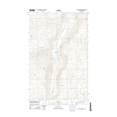
2014 Map of Blue Goat Mountain
USGS Topo · Published 2014About this map
Sinlahekin Valley cuts a prominent north-south corridor through this portion of Okanogan County, flanked by the high summits of Blue Goat Mtn and Aeneas Mtn. This high-country landscape is defined by a series of alpine water bodies, including Blue Lake, Lemanasky Lake, and the managed waters of Sinlahekin Impoundment Number Two. The map details a network of mountain access routes like Douglas Mountain Rd and Lemanasky Rd that navigate the steep drainages of Sarsapkin Cr and N Fork Pine Cr. The presence of Pine Creek Cemetery Rd in the southeast corner points to the area's early settlement history near the drainage of Gibson Cr, while features like Bald Butte and Twin Peaks provide significant landmarks for navigating this wilderness terrain.
Find a feature on this map
28 named features on this map. Tap any name to fly to it.
Don’t see what you’re looking for? This feature index may not catch every label — zoom into the map to look around manually.
Map Details
Editions of this 2014 Blue Goat Mountain Map
This is the sole edition of this map. No revisions or reprints were ever made.
Other maps of this area

1906 · Chopaka
USGS Topo · 1:125,000

1954 · Okanogan
USGS Topo · 1:250,000

1956 · Loomis
USGS Topo · 1:62,500

1956 · Tiffany Mountain
USGS Topo · 1:62,500

1956 · Horseshoe Basin
USGS Topo · 1:62,500

1957 · Conconully
USGS Topo · 1:62,500

1958 · Okanogan
USGS Topo · 1:250,000
1980 · Aeneas Lake
USGS Topo · 1:24,000
1980 · Blue Goat Mtn
USGS Topo · 1:24,000
1981 · Conconully East
USGS Topo · 1:24,000