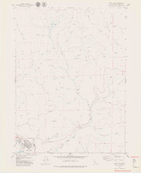
1979 Map of Blue Lake
USGS Topo · Published 1979About this map
Blue Lake sits at the southwestern edge of this 1970s landscape, serving as a focal point for the timber and ranching activities that define the surrounding terrain. The winding Mad River and its major tributary, the North Fork Mad River, carve deep paths through the timberlands, supported by local industrial markers like the Camp Bauer site and various Quarries. North of the town, the ascent toward Liscom Hill and T I P T O P R I D G E reveals a network of high-elevation meadows and plateaus, including Elk Prairie and Round Prairie. These open spaces contrast with the dense drainage systems of Jackson Creek and Canyon Creek, illustrating the varied topography that dictated early settlement patterns. This survey also records specific infrastructure of the era, such as the Sewage Disposal Pond and Water Tanks near the town center, and the Gaging Station monitoring the river flow.
Find a feature on this map
48 named features on this map. Tap any name to fly to it.
Don’t see what you’re looking for? This feature index may not catch every label — zoom into the map to look around manually.
Map Details
Editions of this 1979 Blue Lake Map
3 editions found
Other maps of this area

1922 · Eureka
USGS Topo · 1:62,500

1922 · Korbel
USGS Topo · 1:62,500

1925 · Hoopa
USGS Topo · 1:125,000

1933 · Eureka
USGS Topo · 1:48,000

1942 · Eureka
USGS Topo · 1:62,500

1945 · Trinidad
USGS Topo · 1:62,500

1945 · Coyote Peak
USGS Topo · 1:62,500

1945 · Blue Lake
USGS Topo · 1:62,500

1948 · Weed
USGS Topo · 1:250,000

1949 · Eureka
USGS Topo · 1:250,000