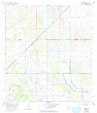
1953 Map of Bluefield
USGS Topo · Published 1993About this map
Allapattah Flats dominates the landscape of this Florida interior, revealing the complex water management systems of the mid-20th century. The topography is defined by a series of drainage canals, a Levee, and a Spoil Bank that cross the county line between St Lucie and Martin Counties. This engineering effort supported the small community of Bluefield and several distinctive high grounds such as Boar Hammock and Myer Hammock.
Find a feature on this map
15 named features on this map. Tap any name to fly to it.
Don’t see what you’re looking for? This feature index may not catch every label — zoom into the map to look around manually.
Map Details
Editions of this 1953 Bluefield Map
4 editions found
Other maps of this area

1953 · Okeechobee 4 SW
USGS Topo · 1:24,000

1953 · Okeechobee 4 SE
USGS Topo · 1:24,000

1953 · Okeechobee 1 SE
USGS Topo · 1:24,000

1953 · Okeechobee 4 NE
USGS Topo · 1:24,000

1953 · Okeechobee 4 NW
USGS Topo · 1:24,000

1953 · Okeechobee 1 SW
USGS Topo · 1:24,000

1953 · Indian Town NW
USGS Topo · 1:24,000

1953 · Fort Pierce SW
USGS Topo · 1:24,000

1953 · Indian Town
USGS Topo · 1:24,000

1956 · Fort Pierce
USGS Topo · 1:250,000