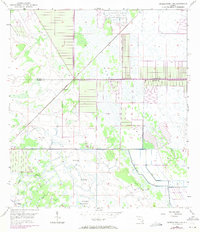
1953 Map of Okeechobee 4 NE
USGS Topo · Published 1971About this map
The Allapattah Flats dominate this interior Florida landscape, where the flat, wet terrain is defined by a network of drainage features and agricultural infrastructure. The settlement of Bluefield sits at a critical intersection where the Florida East Coast rail line cuts diagonally through the marshy expanse. This 1950s survey reflects the engineering of the Florida Everglades and its surroundings, showing the extensive use of Levee systems and canals to manage the water table for land use. Distinctive ecological markers like Myrtle Slough, Boar Hammock, and Myer Hammock indicate slightly elevated ground or drainage patterns in an otherwise level environment. Several instances of a Flowing Well suggest the reliance on artesian water sources for the isolated outposts and farms of the era.
Find a feature on this map
14 named features on this map. Tap any name to fly to it.
Don’t see what you’re looking for? This feature index may not catch every label — zoom into the map to look around manually.
Map Details
Editions of this 1953 Okeechobee 4 NE Map
4 editions found
Other maps of this area

1953 · Okeechobee 4 SW
USGS Topo · 1:24,000

1953 · Okeechobee 4 SE
USGS Topo · 1:24,000

1953 · Okeechobee 1 SE
USGS Topo · 1:24,000

1953 · Okeechobee 4 NE
USGS Topo · 1:24,000

1953 · Okeechobee 4 NW
USGS Topo · 1:24,000

1953 · Okeechobee 1 SW
USGS Topo · 1:24,000

1953 · Indian Town NW
USGS Topo · 1:24,000

1953 · Fort Pierce SW
USGS Topo · 1:24,000

1953 · Indian Town
USGS Topo · 1:24,000

1956 · Fort Pierce
USGS Topo · 1:250,000