
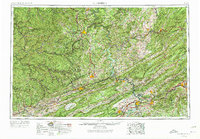
1957 Map of Bluefield
USGS Topo · Published 1967About this map
Bluefield and Princeton anchor this region where the coal-bearing plateau of West Virginia meets the ridge-and-valley topography of Virginia. In the late 1950s, this landscape was defined by the deep-cut river valleys of the New River and Guyandotte River, which served as the primary corridors for massive railroad operations including the Norfolk and Western and the Virginian. The map highlights a network of industrial mining towns like Welch and Mullens, set against the backdrop of protected lands in the Jefferson National Forest and Monongahela National Forest.
Find a feature on this map
127 named features on this map. Tap any name to fly to it.
Don’t see what you’re looking for? This feature index may not catch every label — zoom into the map to look around manually.
Map Details
Editions of this 1957 Bluefield Map
2 editions found
Other maps of this area

1886 · Grundy
USGS Topo · 1:125,000

1887 · Warfield
USGS Topo · 1:125,000

1887 · Pocahontas
USGS Topo · 1:125,000

1887 · Hinton
USGS Topo · 1:125,000

1887 · Lewisburg
USGS Topo · 1:125,000

1889 · Nicholas
USGS Topo · 1:125,000

1889 · Hillsville
USGS Topo · 1:125,000

1889 · Wytheville
USGS Topo · 1:125,000

1890 · Roanoke
USGS Topo · 1:125,000

1890 · Grundy
USGS Topo · 1:125,000