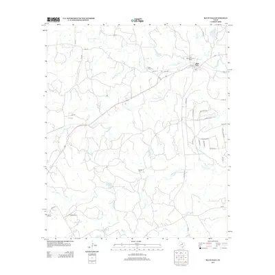
2012 Map of Bluff Dale
USGS Topo · Published 2012About this map
Bluff Dale and its surrounding countryside in Erath County are defined by the winding paths of the Paluxy River, where the N Paluxy River and S Paluxy River converge. The landscape is marked by historic focal points of settlement and memory, including the Bluff Dale Suspension Bridge and several burial grounds such as Wesley Chapel Cem, Acrea Cem, and Knob Hill Cem. To the south, the terrain becomes more structured with the residential developments near Hidden Lk, featuring nautical-themed street names like Blue Marlin Dr and Beacon Lake Dr. The map also captures the functional rural infrastructure of the early 21st century, from the Triangle Ranch to Ratliff Airport, alongside a network of farm-to-market roads like FM-1188 and FM-2481.
Find a feature on this map
48 named features on this map. Tap any name to fly to it.
Don’t see what you’re looking for? This feature index may not catch every label — zoom into the map to look around manually.
Map Details
Editions of this 2012 Bluff Dale Map
This is the sole edition of this map. No revisions or reprints were ever made.
Other maps of this area

1889 · Granbury
USGS Topo · 1:125,000

1890 · Stephenville
USGS Topo · 1:125,000

1920 · Stephenville
USGS Topo · 1:125,000

1931 · Tolar
USGS Topo · 1:62,500

1954 · Dallas
USGS Topo · 1:250,000

1954 · Abilene
USGS Topo · 1:250,000

1958 · Dallas
USGS Topo · 1:250,000

1958 · Abilene
USGS Topo · 1:250,000
1960 · Tolar
USGS Topo · 1:24,000

1961 · Johnsville
USGS Topo · 1:24,000