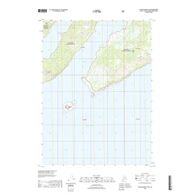
2018 Map of Blying Sound D-3 NW
USGS Topo · Published 2018About this map
Chugach National Forest encompasses the islands and waterways of this maritime environment in the Prince William Sound region. The land is defined by the high relief of Evans Island and Latouche Island, separated by the narrow corridor of Latouche Passage. To the west, the eastern portion of Elrington Island is visible across Elrington Passage. These deep-water channels and sheltered inlets like Montgomery Bay reflect the intricate coastline of the archipelago before it opens into the Gulf of Alaska to the south. Small outcroppings such as Danger Island further characterize the navigational hazards of these subarctic waters, where the landscape remains dominated by natural features and public land management rather than industrial or residential development.
Find a feature on this map
14 named features on this map. Tap any name to fly to it.
Don’t see what you’re looking for? This feature index may not catch every label — zoom into the map to look around manually.
Map Details
Editions of this 2018 Blying Sound D-3 NW Map
This is the sole edition of this map. No revisions or reprints were ever made.
Other maps of this area

1946 · Blying Sound
USGS Topo · 1:250,000

1950 · Blying Sound D-4
USGS Topo · 1:63,360

1951 · Blying Sound
USGS Topo · 1:250,000

1951 · Seward
USGS Topo · 1:250,000

1951 · Seward A-3
USGS Topo · 1:63,360

1951 · Seward A-4
USGS Topo · 1:63,360

1952 · Seward A-3
USGS Topo · 1:63,360

1952 · Seward A-4
USGS Topo · 1:63,360
1952 · Blying Sound D-4
USGS Topo · 1:63,360
1953 · Blying Sound D-3
USGS Topo · 1:63,360