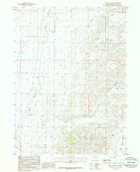
1986 Map of Boars Tusk SW
USGS Topo · Published 1986About this map
Killpecker Creek winds through the high desert of the Wyoming basin, anchoring a landscape defined by dramatic geological formations and essential industrial infrastructure. This 1986 survey records a territory where natural drainage systems like Long Canyon and Crooked Canyon cut through the arid terrain, leading toward the Baxter Basin in the southeast. Human activity is marked by a persistent Trans Line and a dedicated Gravel Pit, signaling the extraction and utility networks supporting the region's energy and transportation sectors. The presence of Dry Lake and features like Prospect reflect the seasonal and speculative nature of the Wyoming landscape, where water is ephemeral and the terrain is closely mapped for its mineral and topographical value during the late twentieth century.
Find a feature on this map
10 named features on this map. Tap any name to fly to it.
Don’t see what you’re looking for? This feature index may not catch every label — zoom into the map to look around manually.
Map Details
Editions of this 1986 Boars Tusk SW Map
This is the sole edition of this map. No revisions or reprints were ever made.
Other maps of this area

1908 · Rock Springs
USGS Topo · 1:62,500

1910 · Rock Springs
USGS Topo · 1:62,500

1954 · Rock Springs
USGS Topo · 1:250,000

1958 · Rock Springs
USGS Topo · 1:250,000

1958 · Boars Tusk
USGS Topo · 1:62,500

1961 · Pilot Butte
USGS Topo · 1:24,000

1962 · Rock Springs
USGS Topo · 1:250,000

1968 · North Baxter
USGS Topo · 1:24,000

1968 · White Rocks
USGS Topo · 1:24,000
1968 · Clay Buttes SE
USGS Topo · 1:24,000