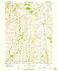
1957 Map of Bogard
USGS Topo · Published 1958About this map
The Chicago Burlington and Quincy railroad cuts a diagonal path across this Carroll County landscape, serving the primary settlement of Bogard and the nearby Aalberg Siding. This late 1950s survey captures a rural Missouri community in a state of transition, evidenced by the presence of Star Sch and Trotter Sch, reflecting the consolidation of local rural school districts.
Find a feature on this map
24 named features on this map. Tap any name to fly to it.
Don’t see what you’re looking for? This feature index may not catch every label — zoom into the map to look around manually.
Map Details
Editions of this 1957 Bogard Map
2 editions found
Other maps of this area

1889 · Lexington
USGS Topo · 1:125,000

1890 · Marshall
USGS Topo · 1:125,000

1892 · Marshall
USGS Topo · 1:125,000

1901 · Marshall
USGS Topo · 1:125,000

1924 · Dawn
USGS Topo · 1:62,500

1924 · Hale
USGS Topo · 1:62,500

1950 · Coloma
USGS Topo · 1:24,000

1950 · Plymouth
USGS Topo · 1:24,000

1951 · Utica
USGS Topo · 1:62,500

1951 · Carrollton East
USGS Topo · 1:24,000