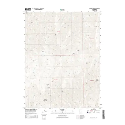
2014 Map of Bogart Canyon
USGS Topo · Published 2014About this map
Mormon Ridge and Went Ridge define the vertical relief of this high-plateau terrain in Grand County, where the landscape is carved by an intricate network of drainages. The area is marked by numerous distinctive natural landmarks, including several named basins such as Surveyors Hole, Beaver Hole, and the evocative Hells Hole. Water sources are localized at points like Oak Springs, feeding into larger systems such as W Willow Cr and Nash Wash. The drainage patterns, including Bogart Canyon and Thompson Canyon, reveal a complex erosion history. These labels suggest a geography historically used by surveyors and local travelers who relied on specific landmarks and intermittent water sources to navigate the canyon-and-ridge system of eastern Utah.
Find a feature on this map
33 named features on this map. Tap any name to fly to it.
Don’t see what you’re looking for? This feature index may not catch every label — zoom into the map to look around manually.
Map Details
Editions of this 2014 Bogart Canyon Map
This is the sole edition of this map. No revisions or reprints were ever made.
Other maps of this area

1885 · East Tavaputs
USGS Topo · 1:250,000

1956 · Grand Junction
USGS Topo · 1:250,000

1959 · Grand Junction
USGS Topo · 1:250,000

1960 · Grand Junction
USGS Topo · 1:250,000

1962 · Grand Junction
USGS Topo · 1:250,000

1963 · Tenmile Canyon
USGS Topo · 1:62,500

1963 · Moonwater Point
USGS Topo · 1:62,500
1963 · Floy Canyon
USGS Topo · 1:62,500

1963 · Sego Canyon
USGS Topo · 1:62,500

1964 · Grand Junction
USGS Topo · 1:250,000