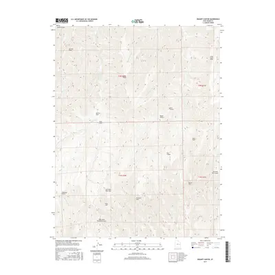
2017 Map of Bogart Canyon
USGS Topo · Published 2017About this map
Mormon Ridge and Went Ridge define the northern drainages of this Grand County landscape, where the high desert is carved into a complex system of deep draws and canyons. The terrain is marked by isolated water sources and natural catchment areas, such as the notably named Hells Hole, Beaver Hole, and Surveyors Hole. These features, along with Oak Springs, suggest the critical importance of water for livestock or early travelers in this arid region. The drainage network is primarily defined by the Nash Wash system and the branching arms of Thompson Canyon, including the Right Hand Thompson Canyon. The lack of established roads or modern structures across these townships emphasizes the persistence of the wilderness character into the early 21st century, as the land remains primarily shaped by natural erosion and the ephemeral flow of creeks like Clear Cr and Fish Cr.
Find a feature on this map
33 named features on this map. Tap any name to fly to it.
Don’t see what you’re looking for? This feature index may not catch every label — zoom into the map to look around manually.
Map Details
Editions of this 2017 Bogart Canyon Map
This is the sole edition of this map. No revisions or reprints were ever made.
Other maps of this area

1885 · East Tavaputs
USGS Topo · 1:250,000

1956 · Grand Junction
USGS Topo · 1:250,000

1959 · Grand Junction
USGS Topo · 1:250,000

1960 · Grand Junction
USGS Topo · 1:250,000

1962 · Grand Junction
USGS Topo · 1:250,000

1963 · Tenmile Canyon
USGS Topo · 1:62,500

1963 · Moonwater Point
USGS Topo · 1:62,500
1963 · Floy Canyon
USGS Topo · 1:62,500

1963 · Sego Canyon
USGS Topo · 1:62,500

1964 · Grand Junction
USGS Topo · 1:250,000