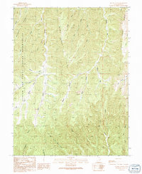
1991 Map of Bogart Canyon
USGS Topo · Published 1991About this map
The eastern reaches of the Uintah and Ouray Indian Reservation dominate the western portion of this terrain, characterized by a series of prominent high-altitude dividers like Mormon Ridge and Wenti Ridge. In this part of Grand County during the early 1990s, the landscape is defined by deep drainages and isolated water sources such as Oak Springs. The map reveals a remote geography of deep cuts and notches, most notably Bogart Canyon and the curiously named depressions of Hells Hole and Surveyors Hole. Settlement is nearly non-existent in this territory, with only The Pines noted as a localized landmark. The intricate network of seasonal flows, including Beaver Wash and Left Hand Nash Wash, illustrates the complex erosion patterns that shape this high plateau country.
Find a feature on this map
29 named features on this map. Tap any name to fly to it.
Don’t see what you’re looking for? This feature index may not catch every label — zoom into the map to look around manually.
Map Details
Editions of this 1991 Bogart Canyon Map
This is the sole edition of this map. No revisions or reprints were ever made.
Other maps of this area

1885 · East Tavaputs
USGS Topo · 1:250,000

1956 · Grand Junction
USGS Topo · 1:250,000

1959 · Grand Junction
USGS Topo · 1:250,000

1960 · Grand Junction
USGS Topo · 1:250,000

1962 · Grand Junction
USGS Topo · 1:250,000

1963 · Tenmile Canyon
USGS Topo · 1:62,500

1963 · Moonwater Point
USGS Topo · 1:62,500
1963 · Floy Canyon
USGS Topo · 1:62,500

1963 · Sego Canyon
USGS Topo · 1:62,500

1964 · Grand Junction
USGS Topo · 1:250,000