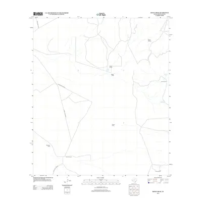
2012 Map of Boggy Draw
USGS Topo · Published 2012About this map
Boggy Draw and Ninemile Draw define the drainage patterns of this high-desert landscape in Jeff Davis County, where water management is the primary marker of human presence. The map reveals a network of vital ranching infrastructure, including several named stock tanks such as Lucky Tank, Dinkins Tank, and the uniquely named String Bean Tank. These features, along with Bunton Windmill and Ninemile Windmill, indicate the ongoing importance of groundwater in a region where surface water is seasonal or ephemeral.
Find a feature on this map
13 named features on this map. Tap any name to fly to it.
Don’t see what you’re looking for? This feature index may not catch every label — zoom into the map to look around manually.
Map Details
Editions of this 2012 Boggy Draw Map
This is the sole edition of this map. No revisions or reprints were ever made.
Other maps of this area

1892 · Chispa
USGS Topo · 1:125,000

1894 · Valentine
USGS Topo · 1:125,000

1895 · Chispa
USGS Topo · 1:125,000

1897 · Valentine
USGS Topo · 1:125,000

1897 · Chispa
USGS Topo · 1:125,000

1943 · Valentine
USGS Topo · 1:125,000

1959 · Marfa
USGS Topo · 1:250,000

1965 · Marfa
USGS Topo · 1:250,000
1978 · Bare Mountain
USGS Topo · 1:24,000
1978 · Herds Pass
USGS Topo · 1:24,000