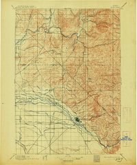
1897 Map of Boise
USGS Topo · Published 1913About this map
Boise serves as the focal point of this late 19th-century survey, revealing a landscape defined by an intricate network of irrigation and early transportation. The city's northern edge is anchored by the Boise Barracks and the Natatorium, while the valley to the west is partitioned by several vital waterways including the Farmers Union Canal, Eureka Canal, and Phyllis Canal. These engineered channels bifurcate the land around Eagle Island, illustrating the foundational water management that allowed settlements like Meridian and Star to take root.
Find a feature on this map
78 named features on this map. Tap any name to fly to it.
Don’t see what you’re looking for? This feature index may not catch every label — zoom into the map to look around manually.
Map Details
Editions of this 1897 Boise Map
4 editions found
Other maps of this area

1892 · Mountain Home
USGS Topo · 1:125,000

1892 · Boise
USGS Topo · 1:125,000

1892 · Bisuka
USGS Topo · 1:125,000

1892 · Silver City
USGS Topo · 1:125,000

1893 · Mountain Home
USGS Topo · 1:125,000

1894 · Bisuka
USGS Topo · 1:125,000

1894 · Silver City
USGS Topo · 1:125,000

1894 · Squaw Creek
USGS Topo · 1:125,000

1894 · Idaho Basin
USGS Topo · 1:125,000

1897 · Boise
USGS Topo · 1:125,000