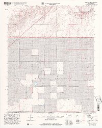
1998 Map of Boise City SW
USGS Topo · Published 2001About this map
Rita Blanca National Grassland dominates this landscape along the border of Oklahoma and Texas, documenting a transition in the High Plains during the late twentieth century. The terrain is defined by the drainage of the Beaver River and Agua Fria Creek, which carve through the shortgrass prairie. The map captures local history through small, grounded landmarks such as the Bertrand Cem and a Gravel Pit, providing essential points of reference for genealogists and local historians. Rural townships like Gresham and Cleveland are noted, alongside the community of Wheeless. This 1998 revision of earlier 1969 topography reflects the enduring agricultural and conservation character of Cimarron County, showing the section lines and roads that organized the panhandle's ranching economy.
Find a feature on this map
10 named features on this map. Tap any name to fly to it.
Don’t see what you’re looking for? This feature index may not catch every label — zoom into the map to look around manually.
Map Details
Editions of this 1998 Boise City SW Map
2 editions found
Other maps of this area

1954 · Dalhart
USGS Topo · 1:250,000

1958 · Dalhart
USGS Topo · 1:250,000

1962 · Dalhart
USGS Topo · 1:250,000

1969 · Boise City
USGS Topo · 1:24,000

1969 · Boise City NW
USGS Topo · 1:24,000

1969 · Boise City SW
USGS Topo · 1:24,000

1969 · Felt
USGS Topo · 1:24,000

1969 · Boise City SE
USGS Topo · 1:24,000

1969 · Felt NE
USGS Topo · 1:24,000

1973 · Buffalo Springs
USGS Topo · 1:24,000