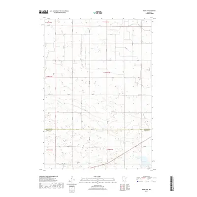
2019 Map of Boise Lake
USGS Topo · Published 2019About this map
Boise Lake anchors the southeastern corner of this rural landscape where the border of Redwood Co and Brown Co meets. The terrain is defined by a dense grid of township and county roads, reflecting the agricultural division of the land into precise sections. Waterways such as Sleepy Eye Cr and Spring Cr meander across this grid, providing drainage for the surrounding fields. Local heritage is preserved in several small burial grounds scattered throughout the townships, including Dannebod Cem and the adjacent Saint Raphael Cem and Saint Rachael Cem. Further south, the Saint Paul Cem sits along the section lines near 200th St. This area remains largely dedicated to farming, with a network of avenues like Porter Ave and Ranch Ave connecting family farms to larger thoroughfares.
Find a feature on this map
41 named features on this map. Tap any name to fly to it.
Don’t see what you’re looking for? This feature index may not catch every label — zoom into the map to look around manually.
Map Details
Editions of this 2019 Boise Lake Map
This is the sole edition of this map. No revisions or reprints were ever made.
Other maps of this area

1953 · Morgan
USGS Topo · 1:62,500

1953 · New Ulm
USGS Topo · 1:250,000

1957 · New Ulm
USGS Topo · 1:250,000

1958 · New Ulm
USGS Topo · 1:250,000

1967 · New Ulm
USGS Topo · 1:250,000

1967 · Clements
USGS Topo · 1:24,000

1967 · Clements SE
USGS Topo · 1:24,000

1967 · Springfield
USGS Topo · 1:24,000

1967 · Sanborn NE
USGS Topo · 1:24,000
1967 · Leavenworth
USGS Topo · 1:24,000