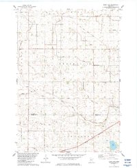
1983 Map of Boise Lake
USGS Topo · Published 1983About this map
Sleepy Eye Creek meanders through the heart of this landscape, marking the transition between the townships of Brookville and Burns near the Redwood Co Brown Co line. In the early 1980s, this region of Minnesota maintained a disciplined agricultural layout defined by an extensive network of drainage projects, including Judicial Ditch No 30 and Judicial Ditch No 36. Transportation history is clearly visible in the landscape, where the Chicago and North Western rail line runs parallel to an Old Railroad Grade in the northern townships.
Find a feature on this map
23 named features on this map. Tap any name to fly to it.
Don’t see what you’re looking for? This feature index may not catch every label — zoom into the map to look around manually.
Map Details
Editions of this 1983 Boise Lake Map
This is the sole edition of this map. No revisions or reprints were ever made.
Other maps of this area

1953 · Morgan
USGS Topo · 1:62,500

1953 · New Ulm
USGS Topo · 1:250,000

1957 · New Ulm
USGS Topo · 1:250,000

1958 · New Ulm
USGS Topo · 1:250,000

1967 · New Ulm
USGS Topo · 1:250,000

1967 · Clements
USGS Topo · 1:24,000

1967 · Clements SE
USGS Topo · 1:24,000

1967 · Springfield
USGS Topo · 1:24,000

1967 · Sanborn NE
USGS Topo · 1:24,000
1967 · Leavenworth
USGS Topo · 1:24,000