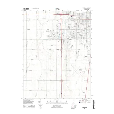
2015 Map of Bondville
USGS Topo · Published 2015About this map
Bondville and the western edge of Champaign anchor this Illinois landscape, showing the transition from dense urban street grids to the structured geometry of agricultural section lines. The presence of the University of Illinois-Willard Airport to the south and Savoy to the east highlights the regional development patterns at the edge of the university influence. The terrain is defined by drainage features such as Twomile Slough, Copper Slough, and the Kaskaskia Ditch, which cut through the flat prairies that define Champaign County. Local heritage and community landmarks are visible in the form of Prairieview Cem and the small enclave of Staley, while the residential growth of Kenwood and recreation at Maynard Lake show the mid-2010s suburban footprint. This survey provides a clear look at the intersection of long-standing farming infrastructure, like Co Road 1500 N, and modern institutions like Mr John's Sch of Cosmetology & Nails.
Find a feature on this map
166 named features on this map. Tap any name to fly to it.
Don’t see what you’re looking for? This feature index may not catch every label — zoom into the map to look around manually.
Map Details
Editions of this 2015 Bondville Map
This is the sole edition of this map. No revisions or reprints were ever made.
Other maps of this area

1906 · Urbana
USGS Topo · 1:62,500

1907 · Mahomet
USGS Topo · 1:62,500

1950 · Tuscola
USGS Topo · 1:62,500

1956 · Villa Grove
USGS Topo · 1:62,500

1957 · Urbana
USGS Topo · 1:62,500

1957 · Urbana
USGS Topo · 1:24,000

1957 · Rising
USGS Topo · 1:24,000

1957 · Mahomet
USGS Topo · 1:62,500

1957 · Bondville
USGS Topo · 1:24,000
1957 · Thomasboro
USGS Topo · 1:24,000