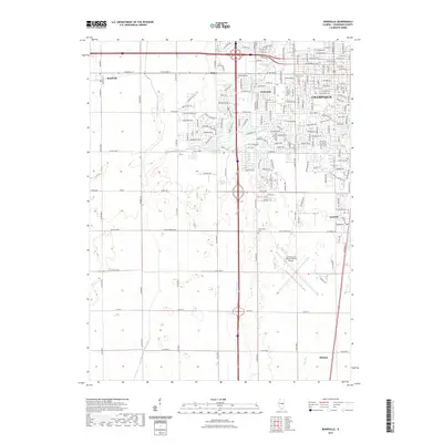
2021 Map of Bondville
USGS Topo · Published 2021About this map
Champaign's western expansion meets the agricultural landscape of Champaign County in this contemporary topographic record. The map details the suburban growth patterns extending toward Kenwood and Staley, where residential developments like Abbey Fields Dr and Brittany Trail Dr contrast with the large-scale industrial and utility footprints of the region. A significant portion of the landscape is dominated by the University of Illinois-Willard Airport, serving as a major regional landmark and transportation hub south of the city.
Find a feature on this map
179 named features on this map. Tap any name to fly to it.
Don’t see what you’re looking for? This feature index may not catch every label — zoom into the map to look around manually.
Map Details
Editions of this 2021 Bondville Map
This is the sole edition of this map. No revisions or reprints were ever made.
Other maps of this area

1906 · Urbana
USGS Topo · 1:62,500

1907 · Mahomet
USGS Topo · 1:62,500

1950 · Tuscola
USGS Topo · 1:62,500

1956 · Villa Grove
USGS Topo · 1:62,500

1957 · Urbana
USGS Topo · 1:62,500

1957 · Urbana
USGS Topo · 1:24,000

1957 · Rising
USGS Topo · 1:24,000

1957 · Mahomet
USGS Topo · 1:62,500

1957 · Bondville
USGS Topo · 1:24,000
1957 · Thomasboro
USGS Topo · 1:24,000