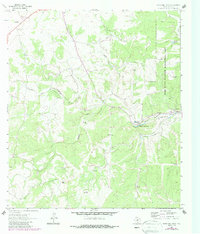
1964 Map of Boneyard Draw
USGS Topo · Published 1987About this map
The North Fork Guadalupe River carves through the central landscape of this West Texas territory, anchoring a network of intermittent watercourses including Boneyard Draw and Indian Creek. In the mid-1960s, this area of Kerr County remained largely ranchland, evidenced by the scattered network of water sources such as the Sampson Windmill and Boneyard Windmill. Local education and community life centered on the Divide Sch, while the eastern portion of the map is dominated by the Kerr State Wildlife Management Area, featuring its own Management Area Hdqrs. The presence of a small Landing Strip and named features like Boneyard Waterhole and Bonnie Belle Lake illustrate the localized water management necessary for livestock and wildlife in this part of the Edwards Plateau. Traces of early land use appear in the form of several small Gravel Pit excavations near the river forks.
Find a feature on this map
26 named features on this map. Tap any name to fly to it.
Don’t see what you’re looking for? This feature index may not catch every label — zoom into the map to look around manually.
Map Details
Editions of this 1964 Boneyard Draw Map
2 editions found

Other maps of this area

1894 · Kerrville
USGS Topo · 1:125,000

1954 · Llano
USGS Topo · 1:250,000

1954 · San Antonio
USGS Topo · 1:250,000

1955 · Llano
USGS Topo · 1:250,000

1956 · Tuff
USGS Topo · 1:62,500

1956 · Llano
USGS Topo · 1:250,000

1957 · San Antonio
USGS Topo · 1:250,000

1963 · Garven Store
USGS Topo · 1:24,000

1963 · Y O Ranch
USGS Topo · 1:24,000

1964 · Hillcrest Ranch
USGS Topo · 1:24,000