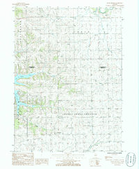
1985 Map of Boone Branch
USGS Topo · Published 1985About this map
Lake Carroll dominates the western landscape of this mid-1980s survey, illustrating a period of recreational development along the border of Stephenson and Carroll counties. The intricate shoreline of the lake, featuring a Golf Course, Camp Ground, and a nearby Landing Strip, reflects a transition toward leisure-oriented land use in this part of Freedom and Cherry Grove-Shannon. Away from the water, the terrain maintains its agricultural character, marked by small settlements like Georgetown, Zier Cors, and Kittredge.
Find a feature on this map
23 named features on this map. Tap any name to fly to it.
Don’t see what you’re looking for? This feature index may not catch every label — zoom into the map to look around manually.
Map Details
Editions of this 1985 Boone Branch Map
This is the sole edition of this map. No revisions or reprints were ever made.
Other maps of this area

1937 · Lena
USGS Topo · 1:48,000

1939 · Freeport
USGS Topo · 1:48,000

1942 · Mt Carroll
USGS Topo · 1:62,500

1942 · Lena
USGS Topo · 1:62,500

1942 · Forreston
USGS Topo · 1:62,500

1943 · Lena
USGS Topo · 1:62,500

1944 · Mt Carroll
USGS Topo · 1:62,500

1944 · Freeport
USGS Topo · 1:62,500

1945 · Forreston
USGS Topo · 1:62,500

1954 · Rockford
USGS Topo · 1:250,000