
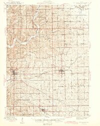
1944 Map of Mt Carroll
USGS Topo · Published 1944About this map
Mt Carroll serves as the focal point for this wartime survey of Northwest Illinois, where the confluence of several major rail lines defined the local economy and settlement patterns. The Chicago Milwaukee St Paul and Pacific crosses the county, intersecting at vital transit points like Ashdale Junc and Kittredge. This network supported a landscape of small agricultural hubs and scattered country schools, such as Hazel Green Sch and Cloverdale Sch, which served the farming townships of Salem and Rock Creek.
Find a feature on this map
74 named features on this map. Tap any name to fly to it.
Don’t see what you’re looking for? This feature index may not catch every label — zoom into the map to look around manually.
Map Details
Editions of this 1944 Mt Carroll Map
2 editions found
Other maps of this area

1891 · Clinton
USGS Topo · 1:62,500

1892 · Savanna
USGS Topo · 1:62,500

1894 · Clinton
USGS Topo · 1:62,500

1899 · Clinton
USGS Topo · 1:125,000

1911 · Elizabeth
USGS Topo · 1:62,500

1930 · Woodsung
USGS Topo · 1:48,000

1934 · Morrison
USGS Topo · 1:48,000

1936 · Elizabeth
USGS Topo · 1:62,500

1937 · Lena
USGS Topo · 1:48,000

1939 · Freeport
USGS Topo · 1:48,000