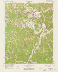
1961 Map of Booneville
USGS Topo · Published 1976About this map
The South Fork Kentucky River defines this 1961 landscape as it carves a deep, winding path past Booneville. The settlement pattern reflects the area's difficult topography, with homesteads and landmarks like the Drive-in Theater concentrated near the riverbanks while the surrounding hills remain defined by resource extraction. Local industry is evident in the numerous strip mines and Oil Wells scattered across the ridges, particularly near Scoville. For those tracing family history, the map provides precise locations for several rural institutions, including Elk Lick Ch, Walnut Grove Ch, and the Fish Creek Sch. Small family-named cemeteries such as Pendergrass Cem and Shepherd Cem are tucked into the valleys of Buck Creek and Meadow Creek, marking the deep roots of this Owsley County community.
Find a feature on this map
50 named features on this map. Tap any name to fly to it.
Don’t see what you’re looking for? This feature index may not catch every label — zoom into the map to look around manually.
Map Details
Editions of this 1961 Booneville Map
3 editions found
Other maps of this area

1891 · Manchester
USGS Topo · 1:125,000

1892 · Beattyville
USGS Topo · 1:125,000

1952 · Tallega
USGS Topo · 1:24,000

1952 · Beattyville
USGS Topo · 1:24,000

1952 · Heidelberg
USGS Topo · 1:24,000

1953 · Oneida
USGS Topo · 1:24,000

1953 · Cowcreek
USGS Topo · 1:24,000

1953 · Mistletoe
USGS Topo · 1:24,000

1953 · Booneville
USGS Topo · 1:24,000

1953 · Sturgeon
USGS Topo · 1:24,000