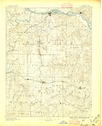
1888 Map of Boonville
USGS Topo · Published 1896About this map
The Missouri River and its numerous islands, including Franklins Island, Gardners Island, and Diana Island, dominate the northern landscape of this late 19th-century survey. The terrain is defined by the heavy dissection of watersheds like Moniteau Creek and Lamine River, which provided the drainage for a landscape transitioning into a rail-centered economy. The Missouri Pacific Railroad cuts a prominent east-west and north-south path across the region, connecting burgeoning trade centers like Boonville, Tipton, and California. Smaller, more isolated settlements like Latham Store, Chouteau Springs, and Pisgah reflect the rural community structure of the 1880s, where local post offices and stores served as the primary hubs between the larger rail-connected towns. This topography reveals the intricate network of creek branches, such as Clarks Fork Creek and Petite Saline Creek, that dictated the placement of these early Missouri roads and farmsteads.
Find a feature on this map
87 named features on this map. Tap any name to fly to it.
Don’t see what you’re looking for? This feature index may not catch every label — zoom into the map to look around manually.
Map Details
Editions of this 1888 Boonville Map
5 editions found
Other maps of this area

1886 · Jefferson City
USGS Topo · 1:125,000

1887 · Sedalia
USGS Topo · 1:125,000

1887 · Warsaw
USGS Topo · 1:125,000

1888 · Versailles
USGS Topo · 1:125,000

1888 · Tuscumbia
USGS Topo · 1:125,000

1888 · Boonville
USGS Topo · 1:125,000

1890 · Moberly
USGS Topo · 1:125,000

1890 · Glasgow
USGS Topo · 1:125,000

1890 · Marshall
USGS Topo · 1:125,000

1892 · Marshall
USGS Topo · 1:125,000