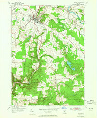
1955 Map of Boonville
USGS Topo · Published 1965About this map
Boonville serves as the focal point of this mid-century survey, situated at the junction of the Black River and several regional transit routes in northern Oneida County. The map details a landscape transitioning from the industrial and agricultural hub of the village to the preserved natural corridors of the Boonville Gorge State Park and various State Reforestation Areas. Notable for genealogists and local historians, the sheet identifies specific rural landmarks such as School No 11, Hayes Ch, and the village Fairgrounds. The topography is defined by significant rises like Potato Hill and Jackson Hill, while the valley floors are traced by the Lansing Kill and Millers Brook. Evidence of local infrastructure includes the Boonville Landing Field and a Gaging Sta along the Black River, alongside smaller settlements like Hawkinsville and North Steuben.
Find a feature on this map
43 named features on this map. Tap any name to fly to it.
Don’t see what you’re looking for? This feature index may not catch every label — zoom into the map to look around manually.
Map Details
Editions of this 1955 Boonville Map
3 editions found
Other maps of this area

1897 · Remsen
USGS Topo · 1:62,500

1900 · Remsen
USGS Topo · 1:62,500

1904 · Boonville
USGS Topo · 1:62,500

1905 · Port Leyden
USGS Topo · 1:62,500

1907 · Port Leyden
USGS Topo · 1:62,500

1912 · Mc Keever
USGS Topo · 1:62,500

1940 · Port Leyden
USGS Topo · 1:62,500

1945 · Boonville
USGS Topo · 1:24,000

1945 · Forestport
USGS Topo · 1:24,000
1946 · West Leyden
USGS Topo · 1:31,680