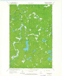
1963 Map of Bootleg Lake
USGS Topo · Published 1965About this map
The Superior National Forest and its complex glacial hydrology define this wilderness area in St. Louis County. The landscape is characterized by an intricate network of drainage and isolated lakes, where the Indian River and Bull Moose River navigate through a terrain of numerous rapids. Named water bodies such as Bootleg Lake, Marvins Lake, and Canthook Lake suggest a history of local exploration or timber harvesting, further evidenced by the series of numeric Ojibwe-derived names like Bezhik, Neesh, and Niswi (one, two, three).
Find a feature on this map
25 named features on this map. Tap any name to fly to it.
Don’t see what you’re looking for? This feature index may not catch every label — zoom into the map to look around manually.
Map Details
Editions of this 1963 Bootleg Lake Map
2 editions found
Other maps of this area

1954 · Hibbing
USGS Topo · 1:250,000

1954 · International Falls
USGS Topo · 1:250,000

1956 · Sioux Pine Island
USGS Topo · 1:24,000

1956 · Chad Lake
USGS Topo · 1:24,000

1956 · Crab Lake
USGS Topo · 1:24,000

1957 · Hibbing
USGS Topo · 1:250,000

1957 · International Falls
USGS Topo · 1:250,000

1958 · International Falls
USGS Topo · 1:250,000

1958 · Hibbing
USGS Topo · 1:250,000

1963 · Astrid Lake
USGS Topo · 1:24,000