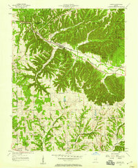
1957 Map of Borden
USGS Topo · Published 1958About this map
Borden sits at the junction of the Muddy Fork and several deeply incised valleys, serving as a focal point for the Monon railroad corridor in the mid-1950s. The landscape is defined by its dramatic relief, with narrow ridges and numerous named hollows such as Packwood Hollow, Mill Hollow, and Salt Well Hollow carving through the terrain. To the north, the protected timberlands of the Clark State Forest cover significant acreage, while the southern portions of the map reveal a rural network of small communities and family landmarks. This 1957 survey provides a detailed view of the border between Clark, Floyd, and Washington counties. Local history is anchored by numerous country churches and cemeteries, including Bear Hill Ch, Daisy Hill Ch, and the combined Chapel Hill Ch (Cem). Notable local features like Hounds Leap and Cubby House Hill suggest a rugged geography that dictated the placement of early settlements like Starlight, Scottsville, and Navilleton.
Find a feature on this map
50 named features on this map. Tap any name to fly to it.
Don’t see what you’re looking for? This feature index may not catch every label — zoom into the map to look around manually.
Map Details
Editions of this 1957 Borden Map
This is the sole edition of this map. No revisions or reprints were ever made.
Other maps of this area

1938 · Speed
USGS Topo · 1:24,000

1939 · New Albany
USGS Topo · 1:24,000

1939 · Georgetown
USGS Topo · 1:24,000

1941 · Borden
USGS Topo · 1:24,000

1946 · New Albany
USGS Topo · 1:24,000

1947 · Speed
USGS Topo · 1:24,000

1947 · Georgetown
USGS Topo · 1:24,000

1949 · Henryville
USGS Topo · 1:24,000

1949 · Georgetown
USGS Topo · 1:24,000

1950 · Salem
USGS Topo · 1:24,000