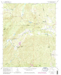
1966 Map of Borden Springs
USGS Topo · Published 1985About this map
Industrial history and rural community life intersect on the border of Alabama and Georgia near Augusta Mine Ridge. This mid-1960s survey records the legacy of iron production at Tecumseh Furnace and the Augusta Mine, while also documenting the recreational and social centers of Borden Springs and Borden Wheeler Springs. The landscape is defined by the Seaboard Coast Line and Southern railroads, which facilitated the movement of goods and people through the ridge-and-valley terrain. Significant portions of the southern map area are preserved within the Talladega National Forest, while the rural uplands are dotted with family-centric landmarks like Harmony Ch, Arrington Chapel, and Cherry Grove Cem. The presence of numerous small lakes, including McGee Lake and Beecham Lake, reflects the drainage patterns of Terrapin Creek and its tributaries.
Find a feature on this map
48 named features on this map. Tap any name to fly to it.
Don’t see what you’re looking for? This feature index may not catch every label — zoom into the map to look around manually.
Map Details
Editions of this 1966 Borden Springs Map
Other maps of this area

1886 · Rome
USGS Topo · 1:125,000

1889 · Tallapoosa
USGS Topo · 1:125,000

1892 · Tallapoosa
USGS Topo · 1:125,000

1893 · Fort Payne
USGS Topo · 1:125,000

1897 · Tallapoosa
USGS Topo · 1:125,000

1898 · Rome
USGS Topo · 1:125,000

1898 · Fort Payne
USGS Topo · 1:125,000

1899 · Rome
USGS Topo · 1:125,000

1900 · Fort Payne
USGS Topo · 1:125,000

1900 · Anniston
USGS Topo · 1:125,000