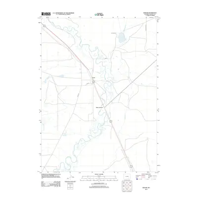
2012 Map of Bosler
USGS Topo · Published 2012About this map
The Laramie River meanders through this high-plains landscape in Albany County, defining a region where water management and ranching operations are central to the local economy. The settlement of Bosler and nearby Bosler Junction serve as the primary hubs along the highway corridor, showing the footprint of human habitation in a predominantly open landscape. Evidence of irrigation and water control is prominent, with the Boughton Canal, Oasis Canal, and James Lake North Canal cutting across the terrain to feed agricultural interests and Diamond Lake. Historical transportation routes like Old Fetterman Rd and Howell Rd connect the isolated Diamond Ranch and other rural holdings to the broader region. This 2012 survey captures the area's transition between the natural river bottom and the engineered landscape of ditches and ranch roads.
Find a feature on this map
13 named features on this map. Tap any name to fly to it.
Don’t see what you’re looking for? This feature index may not catch every label — zoom into the map to look around manually.
Map Details
Editions of this 2012 Bosler Map
This is the sole edition of this map. No revisions or reprints were ever made.
Other maps of this area

1895 · Laramie
USGS Topo · 1:125,000

1902 · Laramie
USGS Topo · 1:125,000

1905 · Laramie
USGS Topo · 1:125,000

1906 · Laramie
USGS Topo · 1:125,000

1908 · Laramie
USGS Topo · 1:125,000

1954 · Cheyenne
USGS Topo · 1:250,000

1955 · Bosler
USGS Topo · 1:24,000

1955 · Bosler SE
USGS Topo · 1:24,000

1955 · Cooper Lake South
USGS Topo · 1:24,000

1955 · Sybille Springs
USGS Topo · 1:24,000