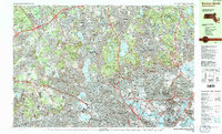
1985 Map of Boston North
USGS Topo · Published 1986About this map
The northern suburbs of Boston are presented here in high-resolution detail during the mid-1980s, showcasing the dense urban and academic landscape of Middlesex and Suffolk counties. Prestigious institutions including Harvard University, Mit, and Tufts University anchor the southern portion of the sheet, while the northern sections reveal the significant protected green spaces of the Middlesex Fells Reservation and Breakheart Reservation. The industrial and transit legacy of the region is evident in the corridors of the Boston and Maine RR and the modern Mbta lines that weave through Somerville and Cambridge. The hydrology of the area is equally prominent, featuring the winding Mystic River and numerous basins like Mystic Lake, Fresh Pond, and Spot Pond which served as critical water resources for the expanding metropolitan area. This survey documents the final years of the 20th century before further modern redevelopment changed these historic neighborhood skylines.
Find a feature on this map
58 named features on this map. Tap any name to fly to it.
Don’t see what you’re looking for? This feature index may not catch every label — zoom into the map to look around manually.
Map Details
Editions of this 1985 Boston North Map
3 editions found
Other maps of this area

1886 · Lawrence
USGS Topo · 1:62,500

1886 · Lowell
USGS Topo · 1:62,500

1886 · Framingham
USGS Topo · 1:62,500

1888 · Lawrence
USGS Topo · 1:62,500

1888 · Salem
USGS Topo · 1:62,500

1889 · Framingham
USGS Topo · 1:62,500

1892 · Boston Bay
USGS Topo · 1:62,500

1893 · Lowell
USGS Topo · 1:62,500

1893 · Salem
USGS Topo · 1:62,500

1893 · Boston
USGS Topo · 1:62,500