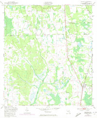
1949 Map of Bostwick
USGS Topo · Published 1972About this map
Bostwick serves as the primary hub of this North Florida landscape, situated along the Seaboard Coast Line corridor during the mid-20th century. The settlement at Hancock and the area of Sun Garden highlight the scattered rural development patterns characteristic of the era, while the Clay Co Putnam Co boundary line divides the northern and southern reaches of the quadrangle. Significant water features like Simms Creek and Clarkes Creek snake through the terrain, suggesting the importance of these drainages for local agriculture and timber.
Find a feature on this map
9 named features on this map. Tap any name to fly to it.
Don’t see what you’re looking for? This feature index may not catch every label — zoom into the map to look around manually.
Map Details
Editions of this 1949 Bostwick Map
5 editions found
Other maps of this area

1912 · Palatka
USGS Topo · 1:48,000

1915 · Palatka
USGS Topo · 1:62,500

1915 · Interlachen
USGS Topo · 1:48,000

1916 · Interlachen
USGS Topo · 1:62,500

1942 · Ates Creek
USGS Topo · 1:62,500

1944 · Interlachen
USGS Topo · 1:62,500

1947 · Bostwick
USGS Topo · 1:50,000

1949 · Rice Creek
USGS Topo · 1:24,000

1949 · Bostwick
USGS Topo · 1:24,000

1949 · Green Cove Springs
USGS Topo · 1:24,000