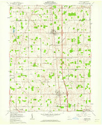
1961 Map of Botkins
USGS Topo · Published 1962About this map
Greenville Treaty Line bisects this section of the Ohio landscape, marking a significant historical boundary between different land survey systems. North of this line, the terrain is organized by the First Principal Meridian under Congress Lands, while the area to the south follows the Miami River Survey. The Baltimore and Ohio railroad serves as the primary industrial spine, connecting the core settlements of Botkins and Anna. This era captures a rural network of family-named roads and burial grounds, including the adjacent Old Loramie Valley Cem and New Loramie Valley Cem near Loramie Creek. Local infrastructure is further defined by various Gravel Pits and a specialized Fish Hatchery, illustrating a mid-century economy rooted in resource management and transport. Small hamlets like Santa Fe and Rumley appear alongside numerous country churches such as Olive Branch Ch, documenting the established social fabric of Shelby and Auglaize counties.
Find a feature on this map
44 named features on this map. Tap any name to fly to it.
Don’t see what you’re looking for? This feature index may not catch every label — zoom into the map to look around manually.
Map Details
Editions of this 1961 Botkins Map
Other maps of this area

1906 · Lima
USGS Topo · 1:62,500

1909 · Loramie
USGS Topo · 1:62,500

1911 · Loramie
USGS Topo · 1:62,500

1911 · Spencerville
USGS Topo · 1:62,500

1913 · Sidney
USGS Topo · 1:62,500

1944 · Sidney
USGS Topo · 1:62,500

1944 · Loramie
USGS Topo · 1:62,500

1944 · Spencerville
USGS Topo · 1:62,500

1953 · Muncie
USGS Topo · 1:250,000

1956 · Muncie
USGS Topo · 1:250,000