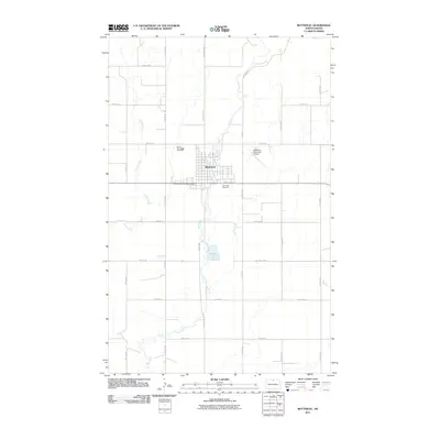
2011 Map of Bottineau
USGS Topo · Published 2011About this map
Bottineau serves as the focal point of this North Dakota landscape, situated at a junction of roads and watercourses in the north-central part of the state. The town's layout is clearly defined, bordered by Mount Saint Mark Cemetery to the northwest and Oak Creek Cemetery to the southeast. The meandering path of Oak Creek bisects the community, while Stone Creek flows through the western rural sections. This 2011 survey illustrates the modern transition of the area, showing the Bottineau Municipal Airport on the eastern edge of town and a grid of rural thoroughfares such as County Rd 49 and Lake Rd. The surrounding terrain is organized into a precise section-line grid, typical of the Great Plains, where agriculture and small-town infrastructure define the local geography.
Find a feature on this map
21 named features on this map. Tap any name to fly to it.
Don’t see what you’re looking for? This feature index may not catch every label — zoom into the map to look around manually.
Map Details
Editions of this 2011 Bottineau Map
This is the sole edition of this map. No revisions or reprints were ever made.
Other maps of this area

1954 · Omemee
USGS Topo · 1:24,000

1954 · Souris SE
USGS Topo · 1:24,000

1954 · Gardena
USGS Topo · 1:24,000

1954 · Minot
USGS Topo · 1:250,000
1955 · Upham NE
USGS Topo · 1:24,000

1955 · Bottineau
USGS Topo · 1:24,000

1955 · Bottineau SE
USGS Topo · 1:24,000

1956 · Metigoshe Lake
USGS Topo · 1:24,000

1956 · Carbury
USGS Topo · 1:24,000

1956 · Lake McArthur
USGS Topo · 1:24,000