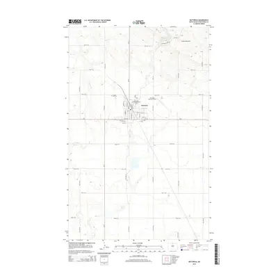
2014 Map of Bottineau
USGS Topo · Published 2014About this map
The city of Bottineau serves as the focal point of this North Dakota landscape, situated where the plains meet the southern edge of the Turtle Mountains. This region is defined by the intersection of state and local transit, with ND-5 running east-west through the heart of the settlement, and Main St and Railroad Ave marking the historic grid. The presence of the Minot State University-Bottineau Campus adds a distinct institutional character to the northern side of town, while the Bottineau Municipal Airport supports regional connectivity to the northeast.
Find a feature on this map
35 named features on this map. Tap any name to fly to it.
Don’t see what you’re looking for? This feature index may not catch every label — zoom into the map to look around manually.
Map Details
Editions of this 2014 Bottineau Map
This is the sole edition of this map. No revisions or reprints were ever made.
Other maps of this area

1954 · Omemee
USGS Topo · 1:24,000

1954 · Souris SE
USGS Topo · 1:24,000

1954 · Gardena
USGS Topo · 1:24,000

1954 · Minot
USGS Topo · 1:250,000
1955 · Upham NE
USGS Topo · 1:24,000

1955 · Bottineau
USGS Topo · 1:24,000

1955 · Bottineau SE
USGS Topo · 1:24,000

1956 · Metigoshe Lake
USGS Topo · 1:24,000

1956 · Carbury
USGS Topo · 1:24,000

1956 · Lake McArthur
USGS Topo · 1:24,000