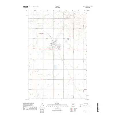
2020 Map of Bottineau
USGS Topo · Published 2020About this map
Bottineau serves as the regional hub at the base of the Turtle Mountains, showing the grid of a developed prairie town characterized by significant public and educational institutions. The presence of Dakota College and the Bottineau County Court House near the center of the community highlights its role as a center for government and higher education in the county. Surrounding the residential core are essential local landmarks, including the Bottineau Municipal Airport to the east and two burial grounds, Mount Saint Mark Cem and Oak Creek Cem. The landscape is defined by the drainage patterns of Stone Cr and Oak Cr, which carve through the relatively level agricultural lands below the rising slopes of the mountains. This 2020 map documents the modern street layout, from the commerce along Main St to the rural roads like Highview Estates Rd that lead into the timbered uplands.
Find a feature on this map
43 named features on this map. Tap any name to fly to it.
Don’t see what you’re looking for? This feature index may not catch every label — zoom into the map to look around manually.
Map Details
Editions of this 2020 Bottineau Map
This is the sole edition of this map. No revisions or reprints were ever made.
Other maps of this area

1954 · Omemee
USGS Topo · 1:24,000

1954 · Souris SE
USGS Topo · 1:24,000

1954 · Gardena
USGS Topo · 1:24,000

1954 · Minot
USGS Topo · 1:250,000
1955 · Upham NE
USGS Topo · 1:24,000

1955 · Bottineau
USGS Topo · 1:24,000

1955 · Bottineau SE
USGS Topo · 1:24,000

1956 · Metigoshe Lake
USGS Topo · 1:24,000

1956 · Carbury
USGS Topo · 1:24,000

1956 · Lake McArthur
USGS Topo · 1:24,000