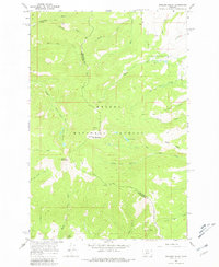
1966 Map of Boulder Baldy
USGS Topo · Published 1981About this map
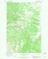
Helena National Forest encompasses the high country of the Big Belt Mountains in the mid-1960s, a landscape defined by sharp elevation shifts and an extensive network of historic pack routes. The boundary between Meagher Co and Broadwater Co runs through the center of the sheet, crossing the northern slopes of Boulder Baldy. This area is characterized by high alpine water bodies like Boulder Lakes and Camas Lake, which feed the drainage systems for Elk Creek and Big Camas Creek. Evidence of early resource exploration remains at a Prospect located on the southern slopes, while old transport corridors like the Confederate Trail and various Pack Trails snake through the drainage of Debauch Gulch and Black Tail Creek, marking the routes used by early travelers before modern roads penetrated these summits.
Find a feature on this map
28 named features on this map. Tap any name to fly to it.
Don’t see what you’re looking for? This feature index may not catch every label — zoom into the map to look around manually.
Map Details
Editions of this 1966 Boulder Baldy Map
3 editions found

Other maps of this area

1886 · Fort Logan
USGS Topo · 1:250,000

1948 · White Sulphur Springs
USGS Topo · 1:250,000
1950 · Duck Creek Pass
USGS Topo · 1:62,500

1958 · White Sulphur Springs
USGS Topo · 1:250,000

1961 · White Sulphur Springs
USGS Topo · 1:250,000

1965 · White Sulphur Springs
USGS Topo · 1:250,000
1966 · Boulder Baldy
USGS Topo · 1:24,000
1966 · Diamond City
USGS Topo · 1:24,000
1966 · Whites City
USGS Topo · 1:24,000

1966 · Watson
USGS Topo · 1:24,000