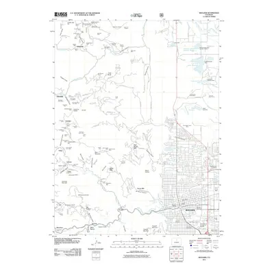
2011 Map of Boulder
USGS Topo · Published 2011About this map
The city of Boulder serves as the focal point of this 2011 survey, where the urban grid meets the complex topography of the Front Range. The presence of Naropa University and the University of Colorado at Boulder highlights the area's established identity as an educational center. To the west, the landscape is defined by a dense concentration of historical mining activity, notably the clusters around Sunshine and Springdale. Features like the Buena Vista Mine Number One and Gold Hill Beryl Claims demonstrate the diversity of mineral extraction in this region.
Find a feature on this map
173 named features on this map. Tap any name to fly to it.
Don’t see what you’re looking for? This feature index may not catch every label — zoom into the map to look around manually.
Map Details
Editions of this 2011 Boulder Map
This is the sole edition of this map. No revisions or reprints were ever made.
Other maps of this area

1899 · West Denver
USGS Topo · 1:125,000

1902 · Boulder
USGS Topo · 1:62,500

1904 · Niwot
USGS Topo · 1:62,500

1904 · Boulder
USGS Topo · 1:62,500

1906 · Blackhawk
USGS Topo · 1:62,500

1942 · Eldorado Springs
USGS Topo · 1:24,000

1942 · Louisville
USGS Topo · 1:31,680

1942 · Tungsten
USGS Topo · 1:24,000

1944 · Eldorado Springs
USGS Topo · 1:31,680
1944 · Tungsten
USGS Topo · 1:31,680