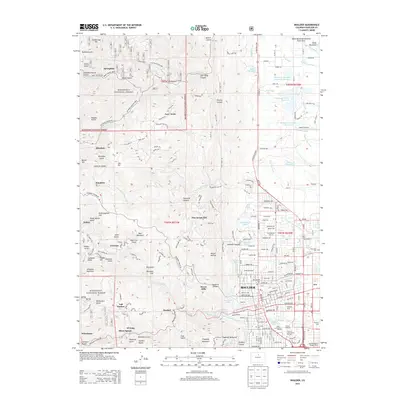
2013 Map of Boulder
USGS Topo · Published 2013About this map
Boulder and the surrounding Front Range foothills are meticulously detailed in this early 21st-century study, showcasing the city's complex interface with the Roosevelt National Forest. The urban layout includes the extensive University of Colorado at Boulder campus, featuring Folsom Stadium and the Mary Rippon Theatre, alongside the Naropa University grounds. Moving west into the mountains, the map reveals a series of historic canyon settlements and mining-era landmarks like Salina, Sunshine, Orodell, and Crisman.
Find a feature on this map
180 named features on this map. Tap any name to fly to it.
Don’t see what you’re looking for? This feature index may not catch every label — zoom into the map to look around manually.
Map Details
Editions of this 2013 Boulder Map
This is the sole edition of this map. No revisions or reprints were ever made.
Other maps of this area

1899 · West Denver
USGS Topo · 1:125,000

1902 · Boulder
USGS Topo · 1:62,500

1904 · Niwot
USGS Topo · 1:62,500

1904 · Boulder
USGS Topo · 1:62,500

1906 · Blackhawk
USGS Topo · 1:62,500

1942 · Eldorado Springs
USGS Topo · 1:24,000

1942 · Louisville
USGS Topo · 1:31,680

1942 · Tungsten
USGS Topo · 1:24,000

1944 · Eldorado Springs
USGS Topo · 1:31,680
1944 · Tungsten
USGS Topo · 1:31,680