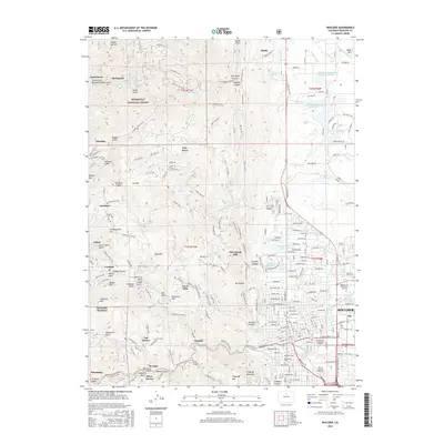
2016 Map of Boulder
USGS Topo · Published 2016About this map
Boulder serves as the focal point for this 2016 survey, where the urban street grid meets the dramatic rise of the Front Range. The map illustrates the city's complex relationship with its topography, showing the extensive trail networks and public lands like the Roosevelt National Forest that buffer the western residential edges. Landmarks such as the Univ of Colorado at Boulder and the Naropa Univ Arapahoe Campus anchor the downtown area, while the Boulder Creek Path traces the waterway through the heart of the settlement. To the west, the landscape is defined by steep gulches and ridges that host scattered mountain communities. Small enclaves such as Pine Brook Hill, Seven Hills, and Crisman are tucked into the drainages of Fourmile Canyon Cr and Boulder Cr. These settlements follow the winding paths of Sunshine Canyon Dr and Boulder Canyon Dr, reflecting a residential pattern dictated by the underlying geology of Bald Mtn and Mt Sanitas.
Find a feature on this map
203 named features on this map. Tap any name to fly to it.
Don’t see what you’re looking for? This feature index may not catch every label — zoom into the map to look around manually.
Map Details
Editions of this 2016 Boulder Map
This is the sole edition of this map. No revisions or reprints were ever made.
Other maps of this area

1899 · West Denver
USGS Topo · 1:125,000

1902 · Boulder
USGS Topo · 1:62,500

1904 · Niwot
USGS Topo · 1:62,500

1904 · Boulder
USGS Topo · 1:62,500

1906 · Blackhawk
USGS Topo · 1:62,500

1942 · Eldorado Springs
USGS Topo · 1:24,000

1942 · Louisville
USGS Topo · 1:31,680

1942 · Tungsten
USGS Topo · 1:24,000

1944 · Eldorado Springs
USGS Topo · 1:31,680
1944 · Tungsten
USGS Topo · 1:31,680