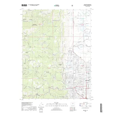
2019 Map of Boulder
USGS Topo · Published 2019About this map
Boulder and the surrounding foothills of the Roosevelt National Forest define this landscape, where the urban grid of the city meets the sharp rise of the Front Range. The map illustrates a complex relationship between the built environment and the steep terrain, centered on the University of Colorado at Boulder and the Boulder County Justice Center. Higher elevation settlements such as Pine Brook Hill, Jamestown, and Sunshine are tucked into the canyons, served by winding routes like Lefthand Canyon Dr. Water management is prominent throughout the region, evidenced by the intricate network of the Silver Lake Ditch, Farmers Ditch, and Anderson Extension Ditch, alongside numerous reservoirs like Wonderland Lake and Maxwell Reservoir that support the local valley. Notable landmarks include Flagstaff Mtn and the historic grounds of Columbia Cem.
Find a feature on this map
229 named features on this map. Tap any name to fly to it.
Don’t see what you’re looking for? This feature index may not catch every label — zoom into the map to look around manually.
Map Details
Editions of this 2019 Boulder Map
This is the sole edition of this map. No revisions or reprints were ever made.
Other maps of this area

1899 · West Denver
USGS Topo · 1:125,000

1902 · Boulder
USGS Topo · 1:62,500

1904 · Niwot
USGS Topo · 1:62,500

1904 · Boulder
USGS Topo · 1:62,500

1906 · Blackhawk
USGS Topo · 1:62,500

1942 · Eldorado Springs
USGS Topo · 1:24,000

1942 · Louisville
USGS Topo · 1:31,680

1942 · Tungsten
USGS Topo · 1:24,000

1944 · Eldorado Springs
USGS Topo · 1:31,680
1944 · Tungsten
USGS Topo · 1:31,680