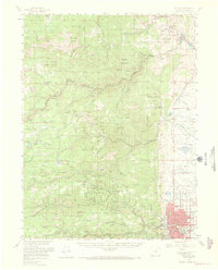
1957 Map of Boulder
USGS Topo · Published 1969About this map
Boulder serves as the focal point for this 1957 survey, showing the city's residential extent and infrastructure before decades of modern expansion. The landscape is defined by the steep canyons and ridges of the Roosevelt National Forest, where numerous mining settlements and small communities like Jamestown, Salina, and Wallstreet are connected by winding mountain roads. Water management is a critical feature, with the Silver Lake Ditch and the Aqueduct system cutting across the topography to support the valley below.
Find a feature on this map
94 named features on this map. Tap any name to fly to it.
Don’t see what you’re looking for? This feature index may not catch every label — zoom into the map to look around manually.
Map Details
Editions of this 1957 Boulder Map
3 editions found
Other maps of this area

1899 · West Denver
USGS Topo · 1:125,000

1902 · Boulder
USGS Topo · 1:62,500

1904 · Niwot
USGS Topo · 1:62,500

1904 · Boulder
USGS Topo · 1:62,500

1905 · Central City
USGS Topo · 1:62,500

1905 · Mount Olympus
USGS Topo · 1:62,500

1906 · Blackhawk
USGS Topo · 1:62,500

1906 · Loveland
USGS Topo · 1:62,500

1907 · Mount Olympus
USGS Topo · 1:62,500

1908 · Loveland
USGS Topo · 1:62,500