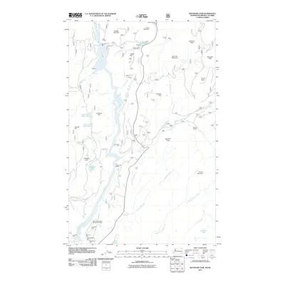
2011 Map of Boundary Dam
USGS Topo · Published 2011About this map
Mining operations and hydroelectric infrastructure dominate the landscape of the Pend Oreille River corridor as it flows north toward the international border. The industrial character of the region is evident in the cluster of mining sites near the southern boundary, including the Pend Oreille Mine, Grandview Mine, and Josephine Mine. Further north, the Boundary Dam stands as a massive engineering feat, complemented by the Pend Oreille Mine Tailings Pond Dam and the nearby Vista House overlook. This 2011 survey captures the transition from the river's deep Z Canyon and dramatic Pewee Falls to the high-elevation ridges of the Selkirk Mountains. Between the river and the border at the Metaline Falls Port of Entry, numerous smaller claims like the Lucky Strike Mine and Riverside Mine are scattered across the timbered slopes. Recreational and natural features such as the Crescent Lake Campground and Ledbetter Lake provide a counterpoint to the heavy extractive footprint of the valley floor.
Find a feature on this map
46 named features on this map. Tap any name to fly to it.
Don’t see what you’re looking for? This feature index may not catch every label — zoom into the map to look around manually.
Map Details
Editions of this 2011 Boundary Dam Map
This is the sole edition of this map. No revisions or reprints were ever made.
Other maps of this area

1934 · Metaline
USGS Topo · 1:125,000

1942 · Metaline
USGS Topo · 1:125,000

1958 · Sandpoint
USGS Topo · 1:250,000

1963 · Sandpoint
USGS Topo · 1:250,000

1967 · Gypsy Peak
USGS Topo · 1:24,000

1967 · Boundary Dam
USGS Topo · 1:24,000

1967 · Metaline
USGS Topo · 1:24,000

1967 · Metaline Falls
USGS Topo · 1:24,000

1967 · Pass Creek
USGS Topo · 1:24,000
1967 · Abercrombie Mtn
USGS Topo · 1:24,000