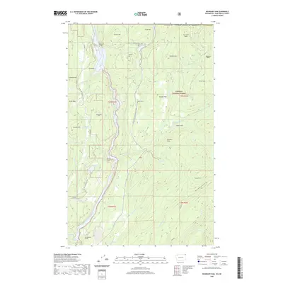
2020 Map of Boundary Dam
USGS Topo · Published 2020About this map
Boundary Dam controls the flow of the Pend Oreille River near the northern edge of Colville National Forest in this 2020 survey. The landscape is defined by the steep-walled Z Canyon and the sharp descent of Pewee Falls, revealing a topography of high ridges and deep gulches. Small upland lakes such as Upper Lead King Lake and Lower Lead King Lake dot the terrain west of the river, while the Pacific NW National Scenic Trail winds through the forest, connecting landmarks like Harvey Grave and Slumber Peak. On the eastern side of the river, the wilderness stretches toward Boundary Ridge and Confusion Ridge, highlighting the isolation of this borderland region where Deadmans Eddy and Whiskey Gulch hint at the area's colorful local nomenclature.
Find a feature on this map
50 named features on this map. Tap any name to fly to it.
Don’t see what you’re looking for? This feature index may not catch every label — zoom into the map to look around manually.
Map Details
Editions of this 2020 Boundary Dam Map
This is the sole edition of this map. No revisions or reprints were ever made.
Other maps of this area

1934 · Metaline
USGS Topo · 1:125,000

1942 · Metaline
USGS Topo · 1:125,000

1958 · Sandpoint
USGS Topo · 1:250,000

1963 · Sandpoint
USGS Topo · 1:250,000

1967 · Gypsy Peak
USGS Topo · 1:24,000

1967 · Boundary Dam
USGS Topo · 1:24,000

1967 · Metaline
USGS Topo · 1:24,000

1967 · Metaline Falls
USGS Topo · 1:24,000

1967 · Pass Creek
USGS Topo · 1:24,000
1967 · Abercrombie Mtn
USGS Topo · 1:24,000