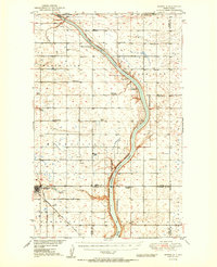
1950 Map of Bowbells
USGS Topo · Published 1950About this map
Upper Des Lacs Lake carves a deep, serpentine path through the North Dakota prairie, serving as the center of the Upper Des Lacs National Wildlife Refuge along the international border. In the late 1940s, the town of Bowbells functioned as a vital railway junction where the Great Northern and the Minneapolis St Paul and Sault Ste Marie railroads intersected. The surrounding landscape is defined by its township-and-range grid, dotted with numerous rural schoolhouses such as Lakeside Sch, Masek Sch, and North Star Sch No 4. This period reflects the post-war development of the Missouri River Basin, evidenced by infrastructure like the CCC Dam on Stony Creek, which managed water resources for the burgeoning agricultural region. The map also records early twentieth-century rural meeting points such as Nine Mile Corner near the Burke and Ward County line.
Find a feature on this map
27 named features on this map. Tap any name to fly to it.
Don’t see what you’re looking for? This feature index may not catch every label — zoom into the map to look around manually.
Map Details
Editions of this 1950 Bowbells Map
2 editions found

Other maps of this area

1947 · Bowbells NW
USGS Topo · 1:24,000

1947 · Tolley
USGS Topo · 1:62,500

1947 · Bowbells
USGS Topo · 1:24,000

1948 · Kenmare
USGS Topo · 1:24,000

1948 · Norma
USGS Topo · 1:24,000

1948 · Coteau
USGS Topo · 1:24,000

1948 · Mouse River Park NW
USGS Topo · 1:24,000

1948 · Vanville NE
USGS Topo · 1:24,000

1949 · Bowbells
USGS Topo · 1:24,000

1949 · Mouse River Park NW
USGS Topo · 1:24,000