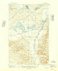
1905 Map of Bowdoin
USGS Topo · Published 1949About this map
Lake Bowdoin dominates this early twentieth-century landscape, surrounded by an intricate system of water management features including several dams and a ditch. The mapping work, performed in part by the Reclamation Service, highlights the transition from natural prairie to an engineered agricultural environment. The Great Northern R R cuts across the center of the sheet, providing a vital transport corridor for the emerging settlements of Bowdoin and Ashfield. To the northeast, Bradys Ranch sits near the tracks, a testament to the era's ranching economy before more intensive irrigation efforts. The rugged Larb Hills rise in the southeast, contrasting with the meandering path of Beaver Creek and the low-lying basins of Lone Tree Lake and Mud Lake.
Find a feature on this map
15 named features on this map. Tap any name to fly to it.
Don’t see what you’re looking for? This feature index may not catch every label — zoom into the map to look around manually.
Map Details
Editions of this 1905 Bowdoin Map
2 editions found
Other maps of this area

1905 · Bowdoin
USGS Topo · 1:62,500

1905 · Saco Special
USGS Topo · 1:62,500

1920 · Cowan
USGS Topo · 1:125,000

1954 · Glasgow
USGS Topo · 1:250,000

1957 · Glasgow
USGS Topo · 1:250,000

1958 · Glasgow
USGS Topo · 1:250,000
1968 · Hewitt Lake
USGS Topo · 1:24,000
1968 · Malta NE
USGS Topo · 1:24,000

1968 · Hewitt Lake SW
USGS Topo · 1:24,000

1968 · Malta East
USGS Topo · 1:24,000