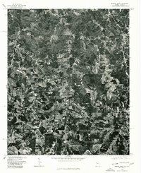
1975 Map of Bowdon West
USGS Topo · Published 1977About this map
Ranburne and Bowdon anchor this mid-1970s orthophotographic study, which captures the rural landscape along the Georgia-Alabama border. Unlike a traditional line-drawn map, this imagery provides a direct look at the patchwork of dense forest and cleared agricultural fields that defined the region during this era. The small settlement of Kansas appears in the northern section, while the label Indian marks a boundary or historical designation in the eastern portion of the quadrangle. The network of winding country roads and isolated farmsteads visible here offers a raw view of the land as it existed before modern suburban expansion began to reach these border communities.
Find a feature on this map
4 named features on this map. Tap any name to fly to it.
Don’t see what you’re looking for? This feature index may not catch every label — zoom into the map to look around manually.
Map Details
Editions of this 1975 Bowdon West Map
This is the sole edition of this map. No revisions or reprints were ever made.
Other maps of this area

1889 · Tallapoosa
USGS Topo · 1:125,000

1892 · Tallapoosa
USGS Topo · 1:125,000

1897 · Tallapoosa
USGS Topo · 1:125,000

1899 · Wedowee
USGS Topo · 1:125,000

1902 · Wedowee
USGS Topo · 1:125,000

1953 · Atlanta
USGS Topo · 1:250,000

1957 · Atlanta
USGS Topo · 1:250,000

1958 · Atlanta
USGS Topo · 1:250,000

1958 · Carrollton
USGS Topo · 1:62,500

1964 · Roopville
USGS Topo · 1:24,000